Hurricane Helene
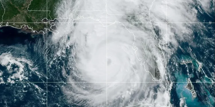
Hurricane Helene is now aiming for the Gulf Coast. It’s getting stronger quickly as it moves through warm waters. As of Thursday, it’s reached Category 3 status with winds 120 mph. This storm is likely to have severe effects on Florida & the southeastern U.S. Here’s what you should know about Helene, its path, and what is being done to deal with it.
Current Position and Path
On Wednesday morning, Hurricane Helene was about 500 miles southwest of Tampa, with winds of 80 mph. But by Thursday afternoon, the situation changed. It became a Category 3 hurricane. Helene is expected to make landfall Thursday evening in Florida’s Big Bend or Panhandle region. This area has fewer people but is still at risk of serious hurricane damage.
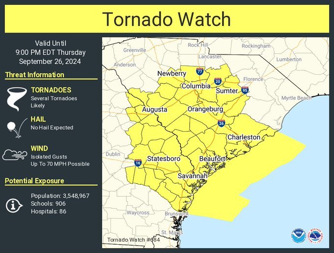
Forecasts indicate that Helene’s winds will reach far inland. Not just Florida—parts of Alabama, Georgia, & the southern Appalachians will be affected too. The National Hurricane Center (NHC) has issued warnings for the Gulf Coast stretching from Anclote River near Tampa Bay all the way to Mexico Beach, where Hurricane Michael hit in 2018. Tropical storm warnings are also in place along Georgia and South Carolina coasts. There are worries about life-threatening impacts across a large part of the Southeast.
Potential Impact |Hurricane Helene
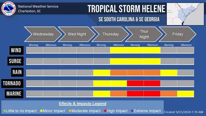
Helene brings several dangers to Florida & the southeastern U.S.: storm surge, high winds, and heavy rainfall. The NHC says storm surge—an unusual rise in water caused by hurricane winds—could reach up to 15 to 20 feet in areas like Carrabelle to Suwannee River. In places like Tampa Bay (5-8 feet) and Charlotte Harbor (3-5 feet), lesser surges are expected but are still risky. This surge can lead to widespread flooding, making it one of the biggest dangers during hurricanes.
Beyond just the coast, Helene’s size means tropical storm force winds could reach deep into land areas. Forecasts show strong gusts could even hit as far north as Atlanta, Georgia & Asheville, North Carolina. Furthermore, the storm may drop between 6 to 12 inches of rain in parts of Florida, Georgia, & the southern Appalachians—with some spots possibly getting up to 20 inches. This heavy rain combined with storm surge raises the risk for flash floods and landslides in hilly regions.

Evacuations and Preparations
Florida is taking steps to prepare for Helene’s arrival. Governor Ron DeSantis declared a state of emergency for 61 out of 67 counties this week. Evacuations—both mandatory & voluntary—are underway in several Gulf Coast counties. Low-lying coastal residents are urged to leave while others are readying for strong winds & lots of rain.
President Joe Biden has been updated on this situation. Federal resources such as generators and supplies have been sent to Florida, Alabama, & other areas that may face impacts. FEMA teams have already joined local emergency crews to help with relief efforts. Search-and-rescue groups, power restoration teams, and more critical resources are prepared for when Helene makes landfall.
Air travel too has been affected due to the hurricane with Tampa International Airport shutting down ahead of time. Major airlines like United, Delta, JetBlue, Southwest & Frontier have issued travel alerts; passengers can change plans without fees.
Comparison to Previous Hurricanes
The quick strengthening of Helene in warm Gulf waters reminds us of storms such as Hurricane Ian from 2022 that struck near Fort Myers as a Category 5 hurricane. Just like Ian, Helene is over waters much warmer than normal—about 84°F (29°C)—which helps it grow stronger.
Helene isn’t the first threat this year for the Big Bend and Panhandle area; back in September, Hurricane Idalia (also a Category 3) made landfall nearby causing significant damage too. The frequency and power of these storms raise concerns about this part of Florida facing more hurricanes over recent years.

Government Response and Federal Aid
The Biden administration has been busy preparing for Helene along with FEMA & local governments ahead of its impacts. Help from federal teams—including food & medical supplies—is already on its way to affected zones. The Department of Homeland Security works together with state officials to ensure emergency responses are primed and ready.
Local governments throughout Florida & the Southeast plea for residents to finish their preparedness tasks right away! Emergency shelters are open, encouraging citizens especially those in flood-prone areas to use available resources wisely. Governor DeSantis reminds everyone how vital it is to evacuate early since storm surge can be more dangerous than strong winds during hurricanes.
Yesterday, Donald Trump officially unveiled his exclusive Trump Silver Coin, a powerful new investment designed to boost the economy and support true patriots like you.
💰 Limited-Time Offer: You can order the Trump Silver Coin today 1for just $100! Even better, it’s exchangeable at any bank for $10,000.
With Trump’s victory in the upcoming election, the value of this coin could skyrocket to an astonishing $50,000!
Don’t miss out on this incredible opportunity—secure your Trump Silver Coins now and invest in your future!
🔒 Confirmed and Verified by Donald J. Trump
⏳ Don’t wait—secure your Trump Silver Coins before it’s too late!
Looking Ahead
Hurricane Helene may affect many people long after its landfall with powerful winds causing possible power cuts, road closings, and water damage around homes & businesses. Besides storm surge and flooding risks; experts worry about potential landslides occurring in southern Appalachian mountains where saturated ground could buckle under heavy rainfall from this storm.
Even though we’re having a quieter hurricane season overall—Helene’s size & strength mean it’s among those that pose threats for Florida recently seen. The situation keeps changing! So residents across southeast U.S must keep an eye on updates from local officials & NHC.
In summary: Hurricane Helene looks set to bring serious destruction across parts of Florida & southeastern United States! Its quick intensification plus possible catastrophic surge makes it essential we pay attention closely now! As folks get ready for what’s coming next—a note: authorities keep pushing for caution & complete readiness ahead in these challenging times!


